

A long-period swell arrives facing the beach on both coasts. Getting there, the seafloor off New Jersey shifts it fifty kilometers down the shore, and the seafloor off San Diego leaves it almost exactly where it was aimed. It all has to do with the bathymetry.
This is the second piece in the First Order series, a tool paired with a simple analysis and reporting to answer a surfing question. This one builds upon the first one. That piece held the seafloor roughly fixed and asked which directions can reach a break, and there refraction, the seafloor’s hand on the swell, was the last correction it added. Here the seafloor is the subject, so refraction moves to the front. There are two explorers now, one for the Southern California Bight and one for the New York Bight, both built over the same real bathymetry, GMRT, so we can start looking at shelf-scale effects on surf.
Zeroth order: the swell goes straight
A swell in deep water does not know the bottom is there. Under each crest the water moves in circles that shrink with depth, and about half a wavelength down the motion is gone. As long as the seafloor stays below that depth the wave rolls on untouched and dead straight. At this order the two coasts are identical, and the seafloor might as well not exist. Everything that separates them happens once the wave starts to feel it.
First order: the bottom steers
Once the seafloor rises into those orbits, the bottom drags and the wave slows. Where one end of a crest slows before the other, the whole crest pivots toward the shallow side, the way a shopping cart pulls to the side with a bad wheel. That pivot is refraction, and it is working on the wave the entire time it is in shallow water, right up until it breaks. Because a wave breaks in a couple meters of water no matter the coast, it arrives nearly straight in no matter the coast. The angle a swell makes with the sand is set by how shallow the water is when it breaks, not by the shelf it crossed to get there, barring very extreme bathymetry.
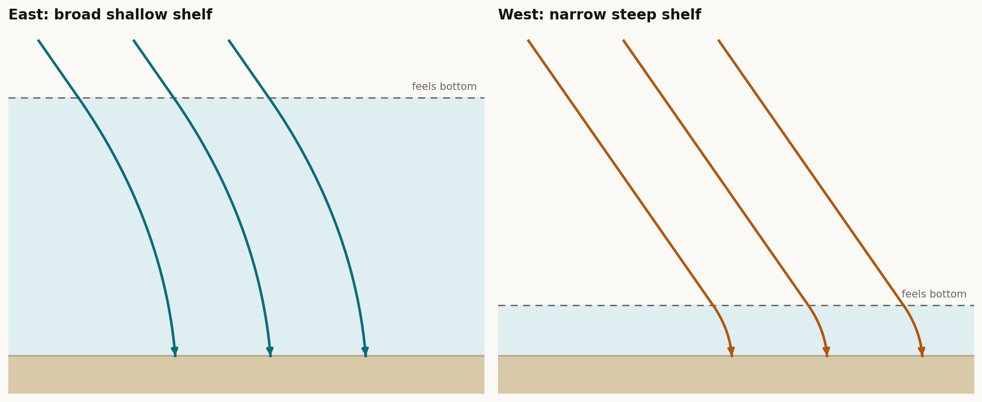
How far out the swell feels the bottom is set by the period, because deep-water wavelength grows with the square of the period. A 6 second swell feels bottom in about 28 meters of water, nearly at the sand. An 18 second swell feels it at 250 meters. So the shelf a long swell has to cross, and the distance over which the bending is spread, is whatever sits above 250 meters. Here is where the two coasts are very different.
The first correction: how much bottom there is to bend over
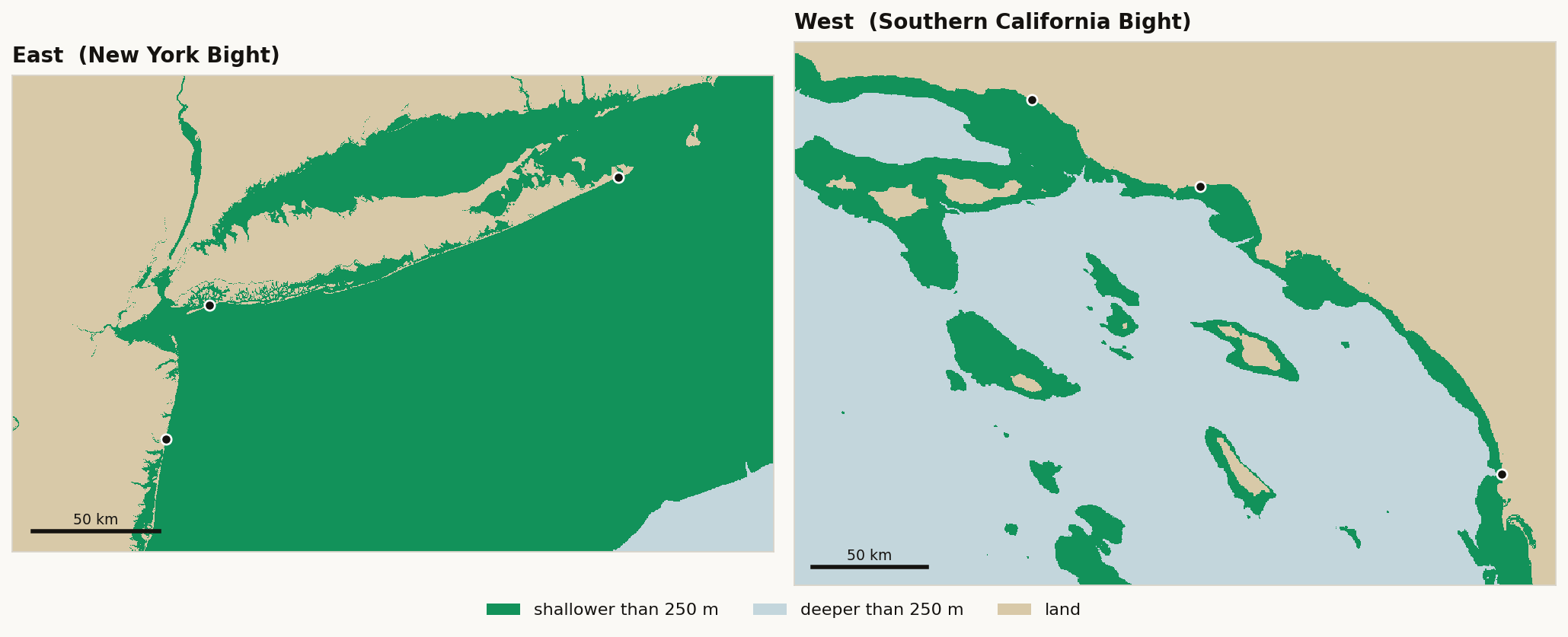
Off New Jersey the shelf barely dips. The 30 meter contour sits about 16 kilometers out at Rockaway and nearly 40 at Long Beach, and 200 meters is more than 90 kilometers offshore, past the edge of the map. An 18 second swell feels bottom the moment it reaches the shelf and keeps feeling it across every remaining kilometer.
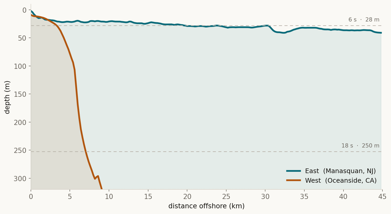
Southern California does the opposite. The bottom falls away almost at once, 30 meters within a few kilometers of most breaks and 200 meters by about six. A swell stays in deep water until the last mile or two, so all of its bending is packed into that thin strip. This shelf is less of a ramp than the lip of a table.
The second correction: early and drawn out, or late and abrupt
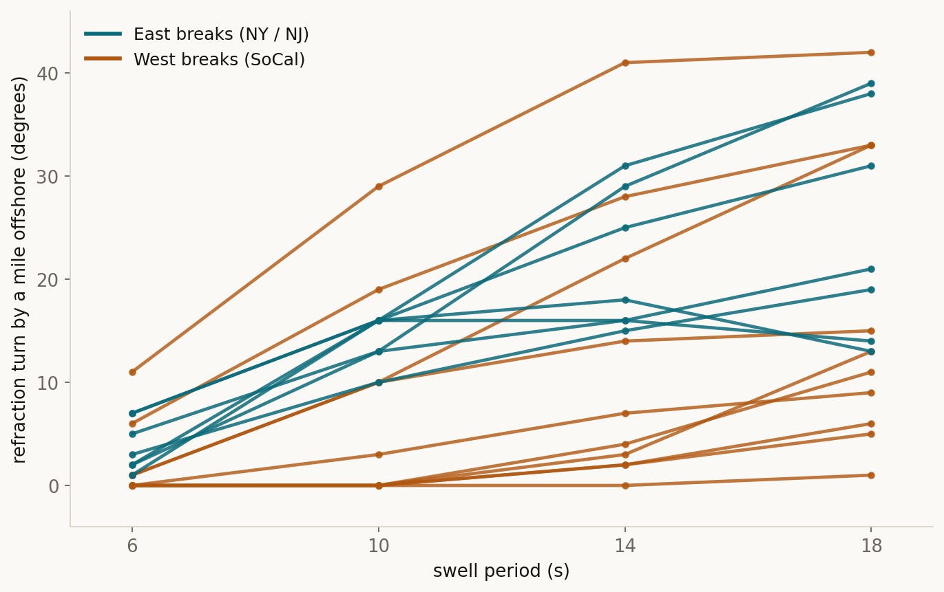
The tools trace each swell from deep water into about a mile offshore and stop there, short of the final approach. By then the East swell is most of the way done turning. Every East break has already bent its 18 second swell 13 to 39 degrees, climbing with period, Manasquan running 1, 16, 31, then 38 across the four periods. By this mark, the West swell has barely started turning. Oceanside, Lower Trestles, and Salt Creek read 6 degrees or less at the same point, not because they bend less in the end but because their bending is all still ahead of them, in the last mile the steep shelf saves it for. The two exceptions, Long Beach and Ventura at 42 and 33, are the West breaks that happen to sit over a wider patch of shelf.
A swell bent gradually across tens of kilometers is also moved as it is turned. The rays show the East swell walked a median of 58 kilometers down the coast between deep water and the beach, coming ashore at a break that a straight line from its deep-water heading would have missed by fifty-some kilometers. The West swell is displaced a median of under two kilometers. It lands close to where it was aimed. In some sense, it is easier to understand the path a swell will take to hit SoCal than the Northeast.
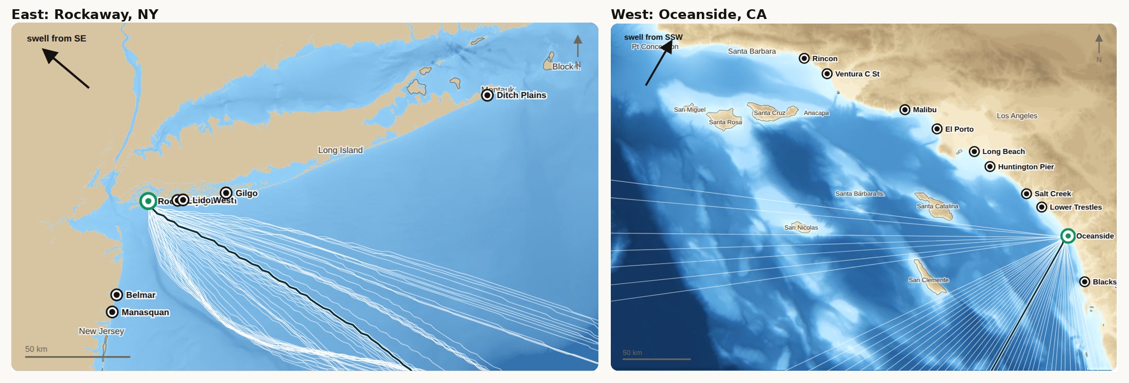
And again with the caveats on this model. A ray is the path energy would take if a swell moved like a beam of light, bending over the seafloor but never spreading sideways. A direction that reaches a break in the tool has a clean, full-strength path in. A direction that misses is not getting nothing: real waves diffract, leaking into the shadows the rays leave empty, weaker but not gone, which is the soft-shadow story from the first piece. Where they crowd together, the seafloor is focusing energy and the surf is bigger; where they fan apart, it is smaller. The rays map which directions arrive at full strength by a direct route, not every bit of energy that reaches the shore.
The takeaway here is that an identical 18 second swell breaks facing the sand on both coasts, but it got there two different ways. Off Oceanside it held its line across deep water and turned in the last mile, landing a stone’s throw from its aim. Off Rockaway it was bent the whole way across a shallow shelf and set down fifty kilometers from where it started pointing.
This is the second piece in the First Order series. The tools are free and open-source; please mess around with them.
Further reading: