

The northeast Pacific is the warmest it has ever been recorded, but May Gray rolled in this year anyway, right on schedule. To me, that pairing seems off. We’ve pulled apart the marine layer before, and we’ve looked at how strange this year’s ocean has gotten, with a heatwave that pushed the basin to 20.6°C last September and still has not left. So here is a fair question: If the gray runs on cold water, why didn’t a record-hot ocean burn it off?
The gray was never really about cold water by itself. It requires cold water at the surface and a band of warmer air parked on top of it like a lid. The bigger the temperature jump between the two, the stronger the lid, and the better it traps the damp air underneath that cools and condenses into our morning cloud. The cold water matters mostly because it widens the gap, which is why our coast, fed by chilly northern water, gets so much more of this than the warm-watered East Coast ever does.
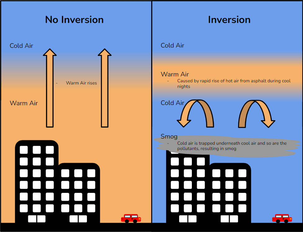
Warming the surface closes the temperature gap some. A smaller jump is a weaker lid, and a weaker lid holds less gray. So yes, warmer water should mean less marine layer. But the honest version of this argument is that the water is not dimming the clouds directly. It is loosening the lid that lets them pool near the coast. Warming waters look like the cloud base creeping higher, until some days it never really commits at all. The sun normally has to chew through a thick gray ceiling but meets a thinner one, and clears it earlier in the day.
You can watch this dial move across a single summer without any heatwave involved. June is the grayest month along the Southern California coast, then the gloom starts surrendering through July. A good chunk of that is the local water warming as the season runs on, and warming faster here than it does up north. Up in Northern California, where the water stays cold longer, the grayest stretch doesn’t show up until July, a full month behind us. The effect happens every year on its own without a heatwave, so a heatwave just turns the same knob harder.
So should the warmest ocean on record hand us a clear June this spring? The 20.6°C headline is mostly a northern, open-water number, with the core of the heat sitting up toward the Gulf of Alaska across something like eight million square kilometers of sea. May Gray answers to a much smaller patch, a thin band of water right off our coast. The California Current still drags cold water down from the north, and upwelling keeps pulling more up from the deep, so the coastal strip can hold its own temperature while the rest of the basin cooks.
It is plausible we get a shorter June Gloom this year, if that warm anomaly works its way down the coast and settles into the water off the Bight. But it leans on a lot of moving parts. Where the warm water actually pools, how hard the coastal winds blow, whether upwelling keeps the nearshore cold, and whether the El Niño now building on top of the heatwave nudges things one way or the other. Whether our particular stretch of coast gets to tan this spring is a toss-up.
Further Reading: